Newsletter numero speciale - Esplorare le isole Eolie: laboratorio INGV di vulcani

La storia sismica delle Isole Eolie
- Dettagli
- Scritto da Francesca Pezzella
Quando pensiamo alle Eolie spesso immaginiamo la loro meravigliosa natura vulcanica; tuttavia esse si trovano in un contesto geodinamico particolare caratterizzato dalla presenza di un sistema crostale di faglie soprastante il cosiddetto slab tirrenico. Questo assetto da luogo a terremoti nel settore del basso Tirreno, ma allo stesso tempo la vicinanza delle Eolie alla terraferma fa si che le isole risentano anche degli eventi sismici che avvengono in Calabria e Sicilia. Per far luce su questi fenomeni abbiamo intervistato Raffaele Azzaro, primo ricercatore dell’Osservatorio Etneo dell’INGV, che si occupa dello studio degli effetti dei terremoti, di sismicità a lungo termine e di faglie attive.
 Raffaele, qual è la storia sismica delle Isole Eolie?
La sismicità delle Isole Eolie è legata alla presenza di due sistemi di faglia: il sistema Sud - Tirrenico, che interessa il basso Tirreno parallelamente alla costa settentrionale siciliana, e quello della cosiddetta Linea di Tindari, una sistema di faglie che attraversa il settore nord-orientale della Sicilia, estendendosi nel Golfo di Patti e quindi marginando a ovest le isole di Vulcano e Lipari.
Le Eolie, quindi, risentono dei terremoti che avvengono su questi due sistemi di faglia ma non solo: sono infatti esposte anche allo scuotimento degli eventi sismici provenienti da Sicilia e Calabria.
Per quanto riguarda l’attività sismica legata al vulcanismo, questa non ha un forte impatto in queste isole come invece avviene nel caso dell’Etna, vulcano caratterizzato da terremoti di magnitudo moderata ma anche distruttivi.
Alcune date di eventi sismici legati a questi sistemi di faglia. Per quanto riguarda il sistema Sud - Tirrenico i terremoti conosciuti che hanno avuto un impatto di rilievo sono avvenuti nel settore occidentale delle Eolie, a Filicudi e Alicudi, nel 1892 e nel 1980. Nel settore orientale delle Eolie invece, nell’area di Stromboli ricordiamo il terremoto del 1941 mentre Lipari e Salina sono state colpite nel 1926 e 1939. Questi eventi, caratterizzati da magnitudo inferiore a cinque, hanno provocato danni lievi.
E invece qual è il tipo di sismicità attuale dell’arcipelago?
Il tipo di sismicità attuale riflette, per grandi linee, quello che già sappiamo dalla sismicità storica. Attraverso la rete sismica installata su tutte le isole dell’arcipelago eoliano registriamo eventi anche di bassa magnitudo, e rileviamo la micro-sismicità legata all’attività vulcanica di Vulcano e Stromboli. A differenza dei terremoti tettonici che si localizzano a profondità di 10-15 km, questi terremoti vulcanici sono estremamente superficiali e di magnitudo anche inferiori a 1.
Ci sono stati eventi sismici particolarmente importanti nella storia di queste isole?
Sì, si tratta degli eventi del 1783, 1894 e 1905, maggiormente risentiti a Stromboli a causa della vicinanza con la Calabria, o più in generale il grande terremoto del 1908 localizzato nello stretto di Messina.
In altri casi, come quello dei terremoti del 1693 che flagellarono l’intera Sicilia orientale, alle Eolie ci furono solo lievi danni.
Per quanto riguarda il Golfo di Patti, l’evento sismico più recente da ricordare è quello del 1978. Con una magnitudo di circa 6, produsse alle Eolie effetti pari al settimo grado della scala Mercalli, il che significa danni diffusi ma non particolarmente gravi.
Cosa ci hanno insegnato questi terremoti?
Questi eventi ci hanno insegnato che le Eolie sono anche soggette all’impatto dei fenomeni sismici. Tuttavia, essendo isole vulcaniche spesso la percezione del rischio è legato ai soli fenomeni eruttivi, ed è quindi facile perdere la memoria di terremoti che avvengono in contesti tettonici apparentemente lontani (Calabria meridionale, Sicilia settentrionale e basso Tirreno), rari nel tempo ma dannosi. E’ bene quindi mantenere l’attenzione e informare cittadini e turisti anche su questo aspetto.
 Che tipo di monitoraggio sismico effettua l’INGV nelle isole?
Nelle Eolie è installata una rete sismica costituita da stazioni per ogni isola dell’arcipelago, proprio al fine di consentire una adeguata localizzazione degli eventi sismici. Questa rete è ovviamente integrata con le stazioni a terra nel settore settentrionale della Sicilia e della Calabria per consentire una migliore localizzazione della sismicità. Nelle isole di Lipari, Vulcano e Stromboli c’è un addensamento del numero di stazioni al fine di “catturare” la micro-sismicità legata alla dinamica dei fluidi magmatici o del magma, come nel caso di Stromboli.
Si tratta in definitiva di una rete a maglia larga con infittimento nelle isole caratterizzate da attività vulcanica.
Per concludere, ci sono dei segni visibili lasciati dagli eventi passati che un occhio attento può osservare?
Sì, ce ne sono due in particolare e si tratta di testimonianze lasciate dall’uomo. Uno si trova a Marina Corta, Lipari, nella chiesa di San Giuseppe dove è presente una lapide in cui si ringrazia il Santo per lo scampato pericolo dal terremoto avvenuto in Calabria nel 1894. La banca dati macrosismica DBMI ci mostra che questo terremoto alle Eolie è stato avvertito senza danni, a differenza di ciò che avvenne in Calabria dove raggiunse il decimo grado della scala Mercalli.
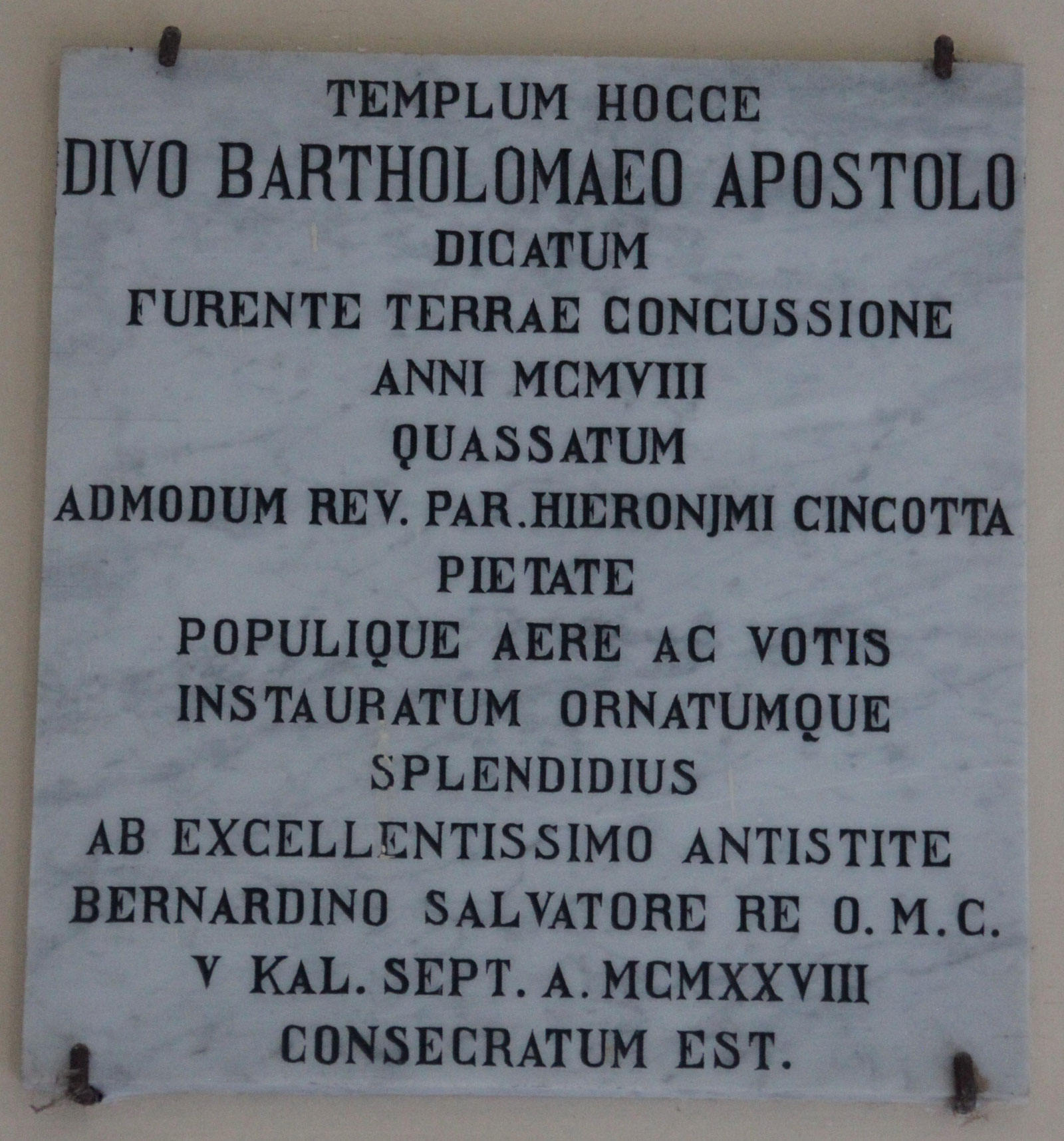
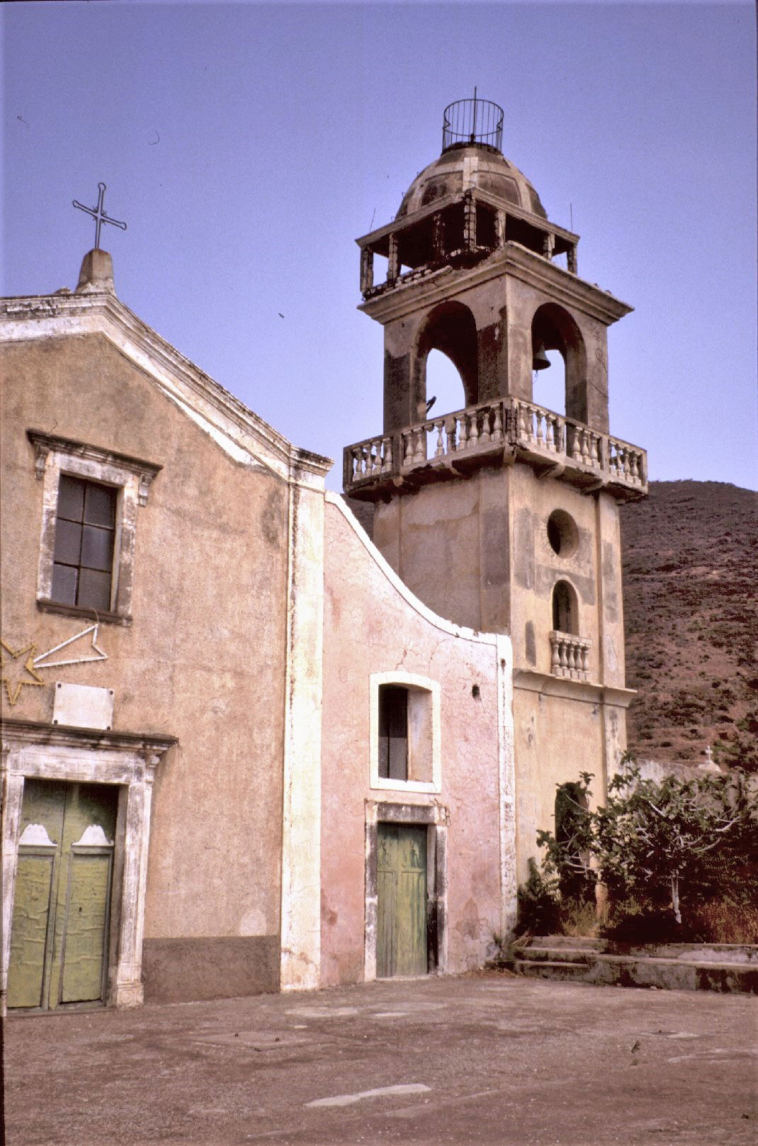
La seconda testimonianza si trova a Stromboli, nella Chiesa di San Bartolo, frazione di San Vincenzo. Qui è esposta una lapide che ricorda che la chiesa è stata restaurata dopo il terremoto di Messina del 1908, evento che a Stromboli ha raggiunto il settimo grado della scala Mercalli.
The seismic history of the Aeolian Islands
When we think of the Aeolian Islands we often imagine their wonderful volcanic nature; however they are found in a particular geodynamic context characterized by tectonicsystems which interfaces with the slab of the Tyrrhenian Sea. This context is responsible for earthquakes but it also occurs that the islands are affected by the seismic events located in Southern Calabria and Sicily. To shed light on these phenomena, we interviewed Raffaele Azzaro, Senior Researcher of the INGV Osservatorio Etneo who studies the effects of earthquakes, long-term seismicity and active faults.
Raffaele, what is the seismic history of the Aeolian Islands?
Seismicity in the region of Aeolian Islands is due to two tectonic systems: the South - Tyrrhenian one, which crosses the lower Tyrrhenian Sea along the northern coast of Sicily, and the Tindari Line, a system of structures cutting the north-eastern sector of Sicily throughout the Gulf of Patti, extending as far as the islands of Vulcano and Lipari.
The Aeolian Islands, therefore, are affected by the earthquakes occurring along these two fault systems, but not only: they are also exposed to the shaking of seismic events from Sicily and Calabria.
As for the seismic activity linked to volcanism, this does not have a strong impact on these islands as it does in the case of Etna, a volcano characterized by moderate magnitude events but capable of producing destructive effects.
Just to mention the most important earthquakes, for the South - Tyrrhenian system we remember, the 1892 and 1980 events which had a significant impact on the western sector of the Aeolian Islands (Filicudi and Alicudi) whereas the eastern sector of the archipelago was hit in 1926 (Lipari and Salina) and 1941 (Stromboli). These latest events, characterized by a magnitude lower than five, caused minor damage.
And what is present seismicity of the archipelago?
The present seismicity roughly mimics the pattern of the historical seismicity. The seismic network installed on the Aeolian Islands is capable of detecting very small magnitude events (not felt by people) the so-called micro seismicity linked to the volcanic activity of Vulcano and Stromboli. Unlike tectonic earthquakes which generally occur at hypocentral depths of 10-15 km, the volcanic earthquakes of the island of Stromboli are extremely shallow and small in terms of energy (magnitude less than 1).
Were there any significant earthquakes in the seismic history of these islands?
Yes, of course. The 1783-1894-1905,events strongly felt in Stromboli due to its proximity to Calabria, or the large 1908 earthquake occurred in the Messina Straits.
In other cases, for istance the 1693 earthquakes which devastated the Eastern Sicily, the Aeolian Islands suffered slight damage only .
As for the Gulf of Patti, the most recent seismic event to be remembered is the one occurred in 1978. With a magnitude of about 6, it produced effects in the Aeolian Islands equal to the degree 7 of the MCSi scale, which means widespread but not particularly severe damage.
What is the lesson of these earthquakes?
These events have taught us that the Aeolian Islands are exposed to seismic risk too. However, being active volcanic islands, people's perception is often focused on the eruptive phenomena only. So it is easy to lose memory of the large earthquakes occurring in regions not so far , rare over time but hazardous. Therefore we need to make aware and inform people on this hazard as well.
What type of seismic monitoring does the INGV perform in the islands?
The Aeolian seismic network consists of several stations for each island of the archipelago, in order to adequately locate the seismic activity. This network is integrated with the network operating in the northern sector of Sicily and Calabria. In the islands of Lipari, Vulcano and Stromboli we have higher the number of stations in order to detect the micro-seismicity linked to the dynamics of magmatic fluids or magma movements, as in the case of Stromboli.
Finally, are there any visible signs left by past events that a keen eye can observe?
Yes, there are two in particular and they are memories left by man.
One is located in Marina Corta, Lipari, in the church of San Giuseppe where there is a plaque in which the saint is thanked for having saved the island from the effects of the 1894 Calabria earthquake. The macroseismic database DBMI confirms that this event was felt in the Aeolian Islands without damage, while in Calabria it reached the degree 10 MCS.
The second evidence is found in Stromboli in the Church of San Bartolo, a hamlet of San Vincenzo. Here there is a plaque reminding that the church was restored after the 1908 Messina earthquake, an event that in Stromboli produced effects of degree 7 MCS.


